Resources
Resources
Browse our guides, industry news, and success stories to optimize your drone operations.
Browse our guides, industry news, and success stories to optimize your drone operations.
Latest helpcenter
Latest helpcenter
How to: Create a Pilot Mission
Plan safe and compliant manual drone flights.
How to: Add Drones to Your Workspace
Adding drones to your library is helpful for multiple reasons. It’ll give you a clear overview of which drones are present within the organization, provide clarity on drones due for maintenance, and enable you to track where each drone has flown, among other benefits. On this page, you will learn how to add new drones and how to edit existing ones.
How to: Report a Drone Incident in AirHub
Reporting incidents, accidents, and hazards is a cornerstone of a strong Safety Management System (SMS). It allows your organization to learn from events, identify trends, and implement corrective actions to prevent future occurrences. Consistent and thorough reporting helps improve operational procedures, enhances safety for your team and the public, and ensures regulatory compliance. AirHub provides two convenient ways to report an incident.
How to: Set Up and Manage a Maintenance Program
Proactive maintenance is critical for ensuring the safety, reliability, and longevity of your drone fleet. The AirHub Maintenance feature provides a comprehensive system to create scheduled maintenance programs, track asset usage against set intervals, and maintain a detailed service history for every asset. This helps you move from reactive repairs to a proactive maintenance culture, reducing downtime and ensuring regulatory compliance.
How to: Edit Maintenance Program
Over time, you may need to update your maintenance programs to reflect changes in your fleet or procedures. Editing a program allows you to modify its details, change the trigger conditions, or, most commonly, add new assets to an existing maintenance schedule. This ensures your maintenance tracking remains accurate as your fleet grows and evolves.
How to: Archiving Maintenance
If a maintenance program is no longer relevant to your operations, for example, if you have retired all assets the program applies to, you can archive it. Archiving removes the program from your active list, keeping your maintenance dashboard clean and focused on current requirements. All historical data associated with the program is preserved.
How to: Read the Weather Advisories
Weather is one of the most important factors influencing the safety and success of any drone operation. A thorough pre-flight weather check is essential to ensure your drone can perform within its operational limits, maintain stability, and comply with aviation regulations. The AirHub weather tool provides detailed, location-specific forecasts to help you make informed go/no-go decisions.
How to: Flyzones
Learn how to create and manage flyzones in AirHub to define safe and compliant flight areas for your drone operations.
How to: Manage Your Drones
Adding drones to your library is helpful for multiple reasons. It’ll give you a clear overview of which drones are present within the organization, provide clarity on drones due for maintenance, and enable you to track where each drone has flown, among other benefits. On this page, you will learn how to add new drones and how to edit existing ones.
How to: Create a Pilot Mission
Plan safe and compliant manual drone flights.
How to: Add Drones to Your Workspace
Adding drones to your library is helpful for multiple reasons. It’ll give you a clear overview of which drones are present within the organization, provide clarity on drones due for maintenance, and enable you to track where each drone has flown, among other benefits. On this page, you will learn how to add new drones and how to edit existing ones.
News
News


What's new
What's new

•
Content
Cockpit & Mission Editor Improvements
We have overhauled the Ground Station experience to give you better situational awareness during flight and more precision during planning.
Mission Editor: POI Heading
Focus on what matters. You can now set the Heading Mode to POI (Point of Interest) within the Mission Editor. simply select a specific coordinate, and the drone will automatically rotate to face that target while flying its waypoints, perfect for inspections and cinematic shots.
Cockpit Improvements
New Status Widgets: Instantly monitor DroneMode and Control State with our cleaner, data-rich widgets.
Sound Cues: You no longer need to stare at the screen to know what’s happening. We’ve added audio alerts to confirm critical events, allowing you to keep your eyes on the aircraft.
Refined Actions: Critical inputs are faster and more reliable. We have improved the Take Picture, Video Recording, Obtain Control, and Pause Mission buttons.
Thermal Zoom: Detail meets data. Thermal view is now fully available while in Zoom mode. This allows you to inspect heat signatures with precision without sacrificing the optical advantage of the zoom lens.
Better Messaging: We’ve updated aircraft messages to be clear and actionable, removing ambiguity.

•
Content
Thermal Palette Control on the DJI Dock
In public safety operations, every second counts and clear information can be the difference between success and failure. We are rolling out a software update for the DJI Dock that improves its thermal imaging capabilities, providing you with a more powerful tool for search and rescue, firefighting, and incident command.
This update gives you direct control over how the thermal camera visualises heat, allowing your team to adapt to rapidly changing tactical situations.
What is the New Feature?
With the latest update, operators can now switch between different thermal color palettes in real-time. Instead of a single, default thermal view, your team can instantly select the visualisation that best suits the mission environment and objective.
Why This Matters for First Responder Missions
This enhanced control provides tangible advantages when deploying the DJI Dock for emergency operations:
Faster Subject Detection in Search & Rescue (SAR): Finding a missing person is a race against time. The ability to switch palettes allows an operator to find the best color contrast to make a human heat signature stand out against challenging backgrounds, whether it's dense foliage at night, a rubble field, or open water. This can significantly reduce search times.
Pinpointing Hotspots and Dangers in Fires: For fire departments, this feature is invaluable. One palette might be ideal for cutting through smoke to identify the seat of a fire, while another can be used during overhaul to find hidden hotspots in walls and ceilings, preventing re-ignition. It also helps in identifying hazardous material tanks that may be overheating.
Improved Situational Awareness for Incident Command: Clear intelligence is key to command decisions. By adjusting the thermal view, you can provide commanders with the most actionable imagery, whether it's tracking a suspect's heat trail, monitoring team locations, or identifying areas that are unsafe for personnel to enter.
Reduced Operator Strain in High-Stress Events: During a prolonged or intense incident, staring at a single thermal display can cause fatigue. Allowing the operator to select a palette that is clearer or more intuitive to them reduces cognitive load, helping them stay focused and effective for longer.

•
Content
Take Control of Your Live Operation: Introducing Resizable Panels in LiveOps
During a live operation, your informational needs can change in an instant. One moment, the primary video feed is your main focus; the next, you're deep in the chat log coordinating ground teams. To support this dynamic workflow, we’re excited to introduce a simple but powerful update to the LiveOps interface: horizontally resizable panels.
What is the New Feature?
You now have the ability to drag and slide the dividers between the main panels in your LiveOps view. This allows you to dynamically change the horizontal size of the:
Map Panel
Livestream Panel
Chat Panel
Shareable Links Panel
The Purpose: A Live Operations View That Adapts to Your Mission
This feature is all about giving you control and allowing you to prioritise your focus based on the task at hand. Here’s why this matters:
Focus on What's Critical: If you are actively piloting a drone or monitoring a critical video feed, you can now expand the Livestream panel to get a larger, more detailed view. You can shrink the chat or links panels to minimise distractions and dedicate more screen real-estate to the live video.
Enhance Situational Awareness: During a wide-area search or when tracking multiple assets, the Map panel is your most important tool. You can now enlarge it to see more of the operational area, track assets more clearly, and review map layers without excessive zooming or panning.
Improve Team Coordination: When an incident requires heavy communication and coordination, a narrow chat window can be frustrating. You can now widen the Chat panel to see more of the conversation history at a glance, reducing the need to scroll and helping you stay on top of rapid-fire messages and updates.
Streamline Information Sharing: If your primary role is managing information for external stakeholders, you can expand the Shareable Links panel to get a clear, organised view of all active links, manage their settings, and share them more efficiently.
This user interface improvement is designed to make the LiveOps platform more flexible and responsive. Your workspace should work for you, not the other way around. With resizable panels, you can instantly configure your view to match the exact needs of your operation.
•
Content
Cockpit & Mission Editor Improvements
We have overhauled the Ground Station experience to give you better situational awareness during flight and more precision during planning.
Mission Editor: POI Heading
Focus on what matters. You can now set the Heading Mode to POI (Point of Interest) within the Mission Editor. simply select a specific coordinate, and the drone will automatically rotate to face that target while flying its waypoints, perfect for inspections and cinematic shots.
Cockpit Improvements
New Status Widgets: Instantly monitor DroneMode and Control State with our cleaner, data-rich widgets.
Sound Cues: You no longer need to stare at the screen to know what’s happening. We’ve added audio alerts to confirm critical events, allowing you to keep your eyes on the aircraft.
Refined Actions: Critical inputs are faster and more reliable. We have improved the Take Picture, Video Recording, Obtain Control, and Pause Mission buttons.
Thermal Zoom: Detail meets data. Thermal view is now fully available while in Zoom mode. This allows you to inspect heat signatures with precision without sacrificing the optical advantage of the zoom lens.
Better Messaging: We’ve updated aircraft messages to be clear and actionable, removing ambiguity.
•
Content
Thermal Palette Control on the DJI Dock
In public safety operations, every second counts and clear information can be the difference between success and failure. We are rolling out a software update for the DJI Dock that improves its thermal imaging capabilities, providing you with a more powerful tool for search and rescue, firefighting, and incident command.
This update gives you direct control over how the thermal camera visualises heat, allowing your team to adapt to rapidly changing tactical situations.
What is the New Feature?
With the latest update, operators can now switch between different thermal color palettes in real-time. Instead of a single, default thermal view, your team can instantly select the visualisation that best suits the mission environment and objective.
Why This Matters for First Responder Missions
This enhanced control provides tangible advantages when deploying the DJI Dock for emergency operations:
Faster Subject Detection in Search & Rescue (SAR): Finding a missing person is a race against time. The ability to switch palettes allows an operator to find the best color contrast to make a human heat signature stand out against challenging backgrounds, whether it's dense foliage at night, a rubble field, or open water. This can significantly reduce search times.
Pinpointing Hotspots and Dangers in Fires: For fire departments, this feature is invaluable. One palette might be ideal for cutting through smoke to identify the seat of a fire, while another can be used during overhaul to find hidden hotspots in walls and ceilings, preventing re-ignition. It also helps in identifying hazardous material tanks that may be overheating.
Improved Situational Awareness for Incident Command: Clear intelligence is key to command decisions. By adjusting the thermal view, you can provide commanders with the most actionable imagery, whether it's tracking a suspect's heat trail, monitoring team locations, or identifying areas that are unsafe for personnel to enter.
Reduced Operator Strain in High-Stress Events: During a prolonged or intense incident, staring at a single thermal display can cause fatigue. Allowing the operator to select a palette that is clearer or more intuitive to them reduces cognitive load, helping them stay focused and effective for longer.
Success stories
Success stories

How FFK used AirHub to coordinate World Cup operations
About FFK Frivilliga Flygkåren (FFK) is Sweden's voluntary aviation corps, with over 2,500 members including more than 800 pilots and observers across the country. FFK provides aerial support to government agencies and emergency services, from search and rescue to infrastructure inspection and large-scale event security.
Frivilliga Flygkåren (FFK)

How Waterschap Zuiderzeeland uses drones for water quality monitoring
Waterschap Zuiderzeeland is the water authority responsible for flood protection, water quality and wastewater treatment in the Dutch province of Flevoland and parts of Friesland and Overijssel. Managing an area of 150,000 hectares, the organisation maintains dikes, waterways, pumping stations and water treatment facilities to keep the region safe, liveable and ecologically healthy.

Waterschap Zuiderzeeland

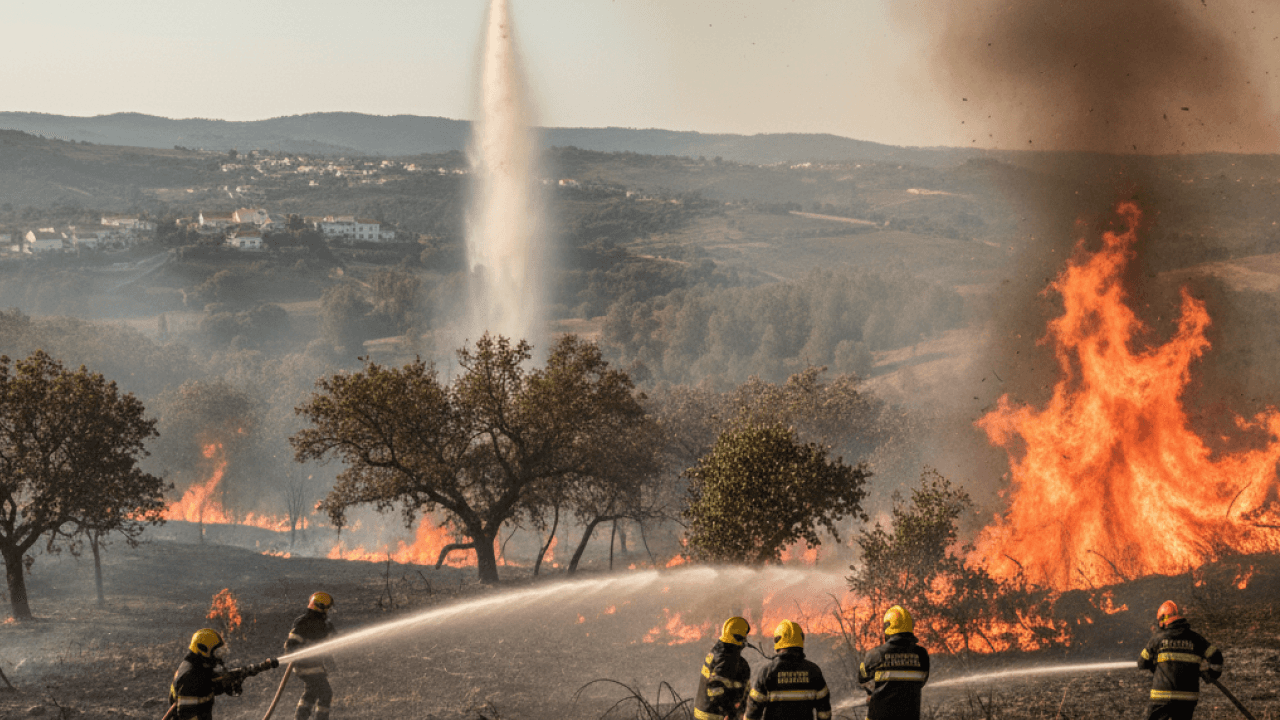
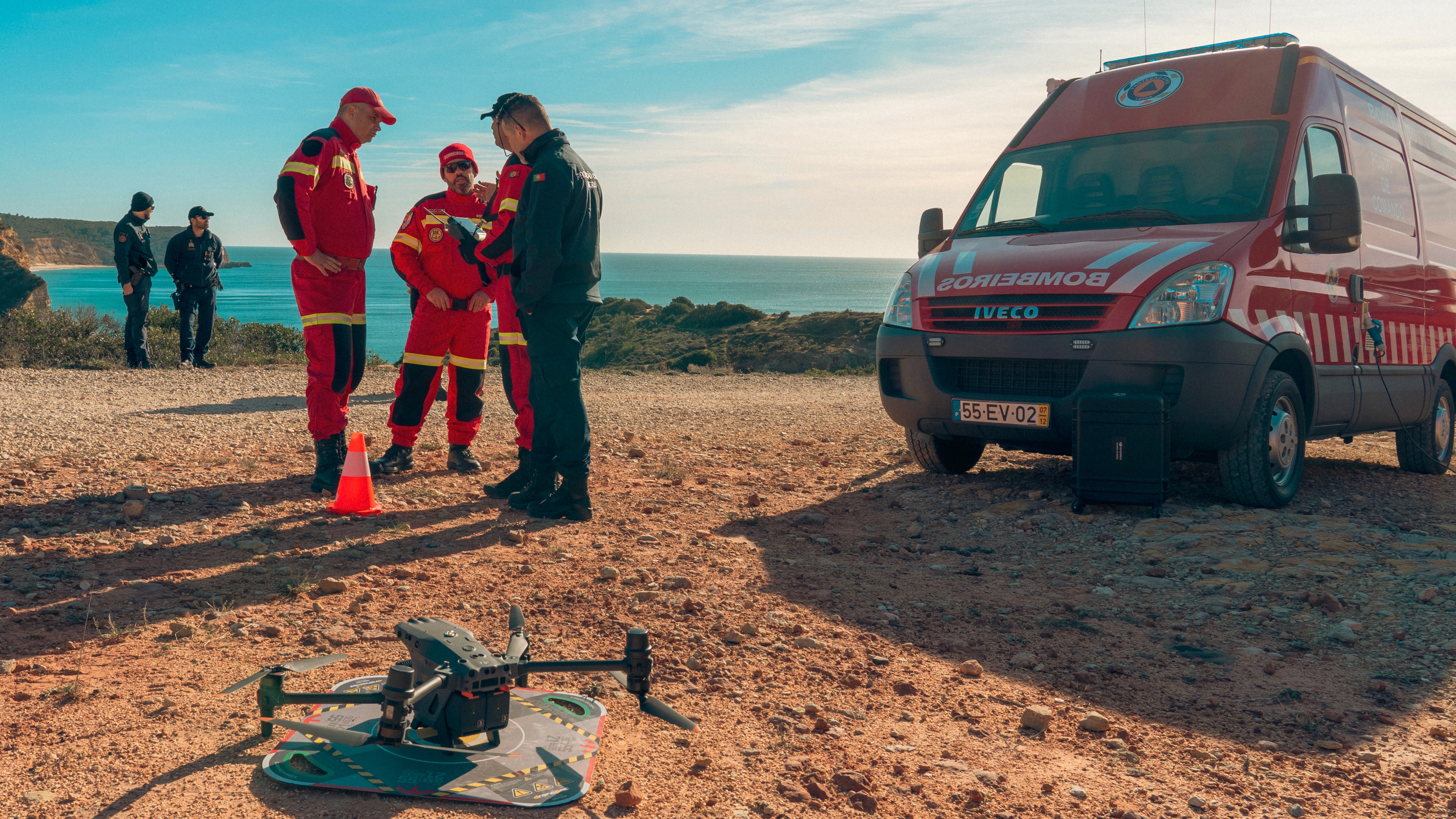
How Portuguese Firefighters use AirHub to coordinate drone operations nationwide
Bombeiros Portugal is the national firefighting and civil protection force, responsible for emergency response across wildfires, urban incidents, and coastal rescues. With one of Europe’s largest public safety drone networks, they use AirHub to manage operations, ensure compliance, and enhance situational awareness during critical missions.

Bombeiros
How FFK used AirHub to coordinate World Cup operations
About FFK Frivilliga Flygkåren (FFK) is Sweden's voluntary aviation corps, with over 2,500 members including more than 800 pilots and observers across the country. FFK provides aerial support to government agencies and emergency services, from search and rescue to infrastructure inspection and large-scale event security.
Frivilliga Flygkåren (FFK)
How Waterschap Zuiderzeeland uses drones for water quality monitoring
Waterschap Zuiderzeeland is the water authority responsible for flood protection, water quality and wastewater treatment in the Dutch province of Flevoland and parts of Friesland and Overijssel. Managing an area of 150,000 hectares, the organisation maintains dikes, waterways, pumping stations and water treatment facilities to keep the region safe, liveable and ecologically healthy.